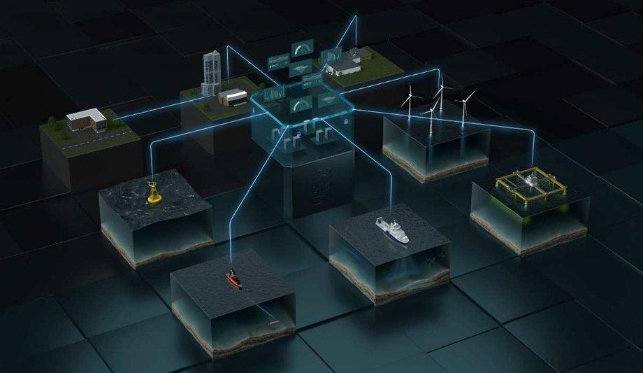
Blue Insight provides an open, modular platform for the processing, visualisation and sharing of ocean data. The core module contains the cloud framework – which has been built to the highest cyber security standards – and an application-specific dashboard teamed with data storage and management functionalities. Additional modules can be added to this framework to tailor Blue Insight’s functionality to suit all projects, however large or small.
Key to Blue Insight’s data-streaming functionality is the concept of sensor fusion, by which data is streamlined from various onboard sensors and a local database for seamless transmission into the cloud. In addition, the module serves as a link with KM onboard sensors for remote operation.
Process
Data can be collected from any platform, ranging from crewed to autonomous surface vessels or even underwater vehicles such as AUVs or gliders.
Through ongoing delivery projects, several modules already exist to assist customers in obtaining the best results from Blue Insight, including Remote, a module that enables remote access to a KM echosounder via a web interface.
Other tools
The portfolio of modules and support for specific instruments will be continuously expanded
Ocean View, a powerful and comprehensive web-based visualisation tool for historic and real-time sensor or database data; and Data Forwarder, enabling data conversion into any common format and automated data forwarding to external cloud systems or databases.
Science Analytics supplies an infrastructure for more in-depth data-handling capabilities, such as the implementation of machine learning and AI-enhanced data analysis on board or in the cloud. As an example, one of the first delivery projects has seen the module providing a framework on unmanned surface vehicles for the automated onboard classification of fish.
The portfolio of modules and support for specific instruments will be continuously expanded, consistent with KM’s aim to provide customers with unprecedently swift access to data, even in heterogeneous environments.
Understanding the impact
One of the first projects to take advantage of the functionality provided by Blue Insight is a collaboration between KM and Akvaplan-niva, gathering meteorological, oceanographic, biological and chemical data from unmanned autonomous glider vehicles.
The project has been underway for several years, but recent funding from the oil & gas company ConocoPhillips Norway has focused efforts towards understanding the impact of offshore oil & gas facilities on selected marine species in the North Sea.
Project development
The project is continuing to evolve the glider concept into an operational system for research and industry while advancing the digital environment to introduce new, cutting-edge management and analysis features.
Blue Insight has been an invaluable aid for managing the vast amount of data collected at sea with the fleet of gliders
"Blue Insight has been an invaluable aid for managing the vast amount of data we collect at sea with our fleet of gliders, often for months at a time,” says Lionel Camus, Manager for Digital Solutions at Akvaplan-niva. “This innovative digital toolbox has enabled Akvaplan-niva to deliver professional solutions and to share an unprecedented common experience via the cloud with our customers during each survey."
Increasing knowledge of the ocean environment
“We’re very excited to be able to bring Blue Insight to market,” adds Tonny Algrøy, Sales Director Ocean Science, Kongsberg Maritime.
“Our primary focus in developing this powerful, cloud-based framework for data collection, sharing and analysis has been to increase our knowledge of the ocean environment and act as a digital enabler for sustainability. It’s great to see that vision now becoming a reality. Collaborations such as the glider project demonstrate how research institutions and industry can work together to benefit from contextualised data, furthering the joint aims of conservation bodies and global business operations.”
